I stood on the shore of the Gila River with Timber and Coins, nervously watching as Google, the tallest of us, attempted to ford the swollen river. It was at least 20 feet across. We couldn’t see the bottom due to silt stirred up by recent rains, and just down stream the water churned into small rapids. Slowly, carefully, Google made his way towards the opposite shore.
Hold on, let me back up. You probably want to know how we got here.
Waiting Out the Weather
With its quaint downtown and $4 burritos, Silver City is obviously an attractive place for hikers. It is the second town stop for most NOBO CDT hikers. It also has an amazing hostel, Triple Crown Hostel, that has everything a hiker could ever want. This town really makes you feel like you’re back in that AT Trail culture experience. Except with fewer hikers.

We took advantage of our timing in town to wait out some nasty weather. Snow was coming in, and we were in a position where we could avoid the worst of it. However, that meant we spent three whole days in town. Three and a half if you count the day we arrived.

Don’t get me wrong – I was grateful to be indoors during that weather. However, I am a hiker, and by the time the weather cleared I was more excited to get out of town than a kid is to get to an amusement park. Maybe it was not hiking for three days, or maybe it was the anticipation of our next section.

The Gila
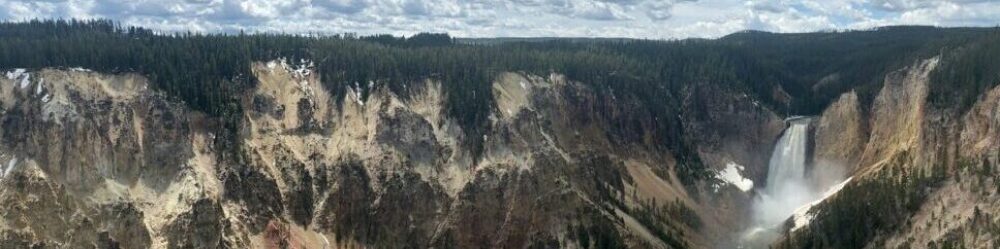
It was something I’d only ever read about. Something that was talked about with a certain reverence, as if it were one of the last truly unique places in this world. The Gila National Forest and Wilderness Area. I was finally there. I was giddy – like a school kid on their first date. Even a thin layer of snow remained from the day before! It was beautiful, and I hadn’t even reached the best part yet.

The defining feature of the Gila National Forest is the Gila River. It is revered among hikers for its width, hundreds of crossings, and of course, beauty. The river itself is a massive tributary to the Colorado River and is 650 miles long. It rests in the nations very first designated wilderness area. Any remaining doubt I had about how special this place is has vanished.

It took us two days to trek from Silver City to the place where the CDT intersects the river. We went from worrying about how long our water carries would be, to only carrying a liter at a time. Water is abundant in this National Forest, especially this time of year. It probably helped that we were coming into it right behind two days of rain. While this was a huge treat leading up to the Gila River, once we got there it bit us in the butt. In the small stretch that we would follow the Gila to Doc Campbell’s, we would have to cross the river 48 times.
All Aboard the Bail Trail
This brings us back to where we started. Where was I? Oh, right, Google.
He was about halfway across. The water only came up to about the middle of his thigh. Not impossible by any means. We watched in silence, hoping and praying it didn’t get any higher. The river rushed around him, threatening to dislodge his footing each time he advanced. With each progressive step, Google sank deeper into the river. It was at his waist, then his belly button, then he stumbled.

He regained his footing quickly, and rushed to the safety of the bank. From our side, we could see the water line at Google’s chest. The whole bottom of his pack had been submerged. Google has 8 inches on me. If the water was that high on him, I would be swimming. He turned and looked at us. In unison, we all vigorously shook our heads. There was no way we were getting across that.
We knew this might happen, and had planned an alternate route just in case. We’ve fondly nicknamed it “the bail trail.” I did not particularly want to take this route. I’d been looking forward to this section since before I knew I was hiking the CDT. Skip it? What? Inconceivable!
It Really Wasn’t That Bad
Safety comes first, so skip it we did. Our bail out route took us up high and out to the east. It crossed a smaller creek eight times before dumping us out on Rt. 15, 14 miles south of Doc Campbell’s Post, where we would rejoin the CDT. My disappointment at having to take this route lasted about as long as it took us to climb to the top of the canyon, where it was replaced by complete amazement.

To think I’d ever doubted the beauty of this route is blasphemy. Being up that high, we were afforded with a birds eye view of the wilderness. It was breathtaking. It was unlike anything I’ve ever seen before. Pictures will likely not do it justice, and my words might not be enough either, but I will try.

The river snakes through a steep, winding valley hundreds of feet below us. The sound of it cascading through the canyon rushes up to meet our ears as we gaze down and out. Lining the waters’ edge are pale sycamore trees in the midst of their winter hibernation. Junipers and ponderosa pines take up the remaining ground and accompany the brown rock of the valley with lush shades of green. Around each bend, we see a new expanse of peaks and valleys. The scene just makes me look forward to coming back here that much more.

Even the road walk to Doc’s wasn’t that bad. I mean, it was still a road walk, but it was infinitely nicer than the road walk into Silver City.
The End of the Section
Past Doc Campbell’s, it would be another short road walk to the end of our section. We rewarded ourselves with a stay at the Gila Hot Springs Campsite. It’s exactly how it sounds; camping with hot springs. I took full advantage of the three natural pools to soak away my road walk muscle aches.

The next day, I did the 3 miles to our finish line and was rewarded with a ride to the Cliff Dwellings. A one mile loop trail takes you up and into the six rooms of the dwellings. This short stroll through history was a classic ending to our anything-but-typical section hike of the CDT.

So Now What?
Well, we aren’t quite sure yet. We still have about two weeks until we start the GWL with the rest of the team. For now, we’re recouping in our favorite place to zero and coming up with a game plan for now until Phoenix. I don’t know exactly what it will look like, but I can say it will probably be awesome. So stay tuned, because we’re just getting warmed up.

I am fundraising for NAMI NH during this hike. Check out the links either on the homepage or in the footer to donate and get us closer to our goal!
Hi Erica (spitefire),
Your photos and descriptions are awesome. I think you are awesome and I admire you fortitude . Good luck and be safe..
Love aunt martha